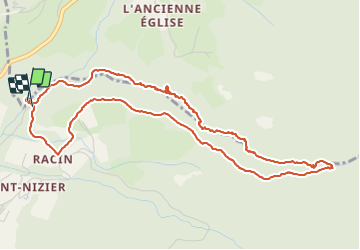
![](/images/other/stat-length.png)
![Trail Walking La Sure en Chartreuse - Gorges de la Roize Voreppe - Photo](https://media.geolcdn.com/t/1900/400/a5350fa4-d9ed-4773-a96d-a6a92f5033ea.jpg&format=pjpeg&maxdim=2)
Gorges de la Roize Voreppe
cousam
User
![Length](/images/other/stat-length.png)
![Max alt](https://static1.geolcdn.com/siteimages/upload/files/1508320355ic_sort_altitude_max_24dp.png)
![Uphill gradient](https://static1.geolcdn.com/siteimages/upload/files/1508320355ic_sort_den_pos_24dp.png)
![Km-Effort](/images/other/stat-length.png)
![Min alt](https://static1.geolcdn.com/siteimages/upload/files/1508320355ic_sort_altitude_min_24dp.png)
![Downhill gradient](https://static1.geolcdn.com/siteimages/upload/files/1508320355ic_sort_den_neg_24dp.png)
![Boucle](https://static1.geolcdn.com/siteimages/upload/files/16400158638029165_repeat_loop_refresh_sync_direction_icon.png)
![Walking](https://static1.geolcdn.com/sitytour/trail-icons/101.png)
3h21
Difficulty : Medium
![Scan this QR Code to open this trail in the SityTrail application](https://capi.geolives.com/qq0zvz2zws4bq2lad0pu/sitytour/trails/2839424/qr.png?size=200)
FREE GPS app for hiking
About
Trail Walking of 6.1 km to be discovered at Auvergne-Rhône-Alpes, Isère, La Sure en Chartreuse. This trail is proposed by cousam.
Description
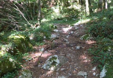
Remontée de la Roize par la rivière (assez difficile) mais sympa.
prévoir corde 10M pour le dernier passage du gros boc avec 2 troncs d'arbre comme échelle (1 seul barreau... QQ clous)
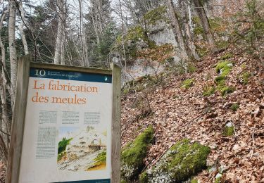
Retour par le sentier balisé.
PS: Rando prise sur topo de Pascal Sombardier
Positioning
Comments
Trails nearby
![Trail Walking Voreppe - Le Rocher de Lorzier, 1838m - Photo](https://media.geolcdn.com/t/375/260/ext.jpg?maxdim=2&url=https%3A%2F%2Fservices.sitytrail.com%2FGeolivesWS%2FDownloadMedia.ashx%3FTrailID%3D105680%26Media%3D9506_1.jpg)
![Walking Walking](https://static1.geolcdn.com/sitytour/trail-icons/101.png)
Walking
![](/images/other/stat-length.png)
![](https://static1.geolcdn.com/siteimages/upload/files/16400158638029165_repeat_loop_refresh_sync_direction_icon.png)
![Trail Walking Voreppe - 38 voreppe - Photo](https://media.geolcdn.com/t/375/260/ae534631-eaae-45ff-8bde-8ca8e28aadbe.jpg&format=jpg&maxdim=2)
![Walking Walking](https://static1.geolcdn.com/sitytour/trail-icons/101.png)
Walking
![](/images/other/stat-length.png)
![](https://static1.geolcdn.com/siteimages/upload/files/16400158638029165_repeat_loop_refresh_sync_direction_icon.png)
![Trail Walking Voreppe - chalet des bannette par la cheminée et le pas de l'âne - Photo](https://media.geolcdn.com/t/375/260/1e724d55-35f1-431a-a226-5d4d8430026f.jpg&format=jpg&maxdim=2)
![Walking Walking](https://static1.geolcdn.com/sitytour/trail-icons/101.png)
Walking
![](/images/other/stat-length.png)
![](https://static1.geolcdn.com/siteimages/upload/files/16400158638029165_repeat_loop_refresh_sync_direction_icon.png)
![Trail Walking Voreppe - 38 la roize - Photo](https://media.geolcdn.com/t/375/260/aa413979-8680-4ab9-a3c8-d00868a6c4b7.jpg&format=jpg&maxdim=2)
![Walking Walking](https://static1.geolcdn.com/sitytour/trail-icons/101.png)
Walking
![](/images/other/stat-length.png)
![](https://static1.geolcdn.com/siteimages/upload/files/16400158638029165_repeat_loop_refresh_sync_direction_icon.png)
![Trail Electric bike Voreppe - voreppe saint julien le grand raz voreppe - Photo](https://media.geolcdn.com/t/375/260/ext.jpg?maxdim=2&url=https%3A%2F%2Fstatic1.geolcdn.com%2Fsiteimages%2Fupload%2Ffiles%2F1524743154velo.jpg)
![Electric bike Electric bike](https://static1.geolcdn.com/sitytour/trail-icons/205.png)
Electric bike
![](/images/other/stat-length.png)
![](https://static1.geolcdn.com/siteimages/upload/files/16400158638029165_repeat_loop_refresh_sync_direction_icon.png)
![Trail Walking Voreppe - Rocher de Lorzier - Photo](https://media.geolcdn.com/t/375/260/44d1aac1-481d-4e20-af4b-16c5baf65295.jpg&format=jpg&maxdim=2)
![Walking Walking](https://static1.geolcdn.com/sitytour/trail-icons/101.png)
Walking
![](/images/other/stat-length.png)
![](https://static1.geolcdn.com/siteimages/upload/files/16400158638029165_repeat_loop_refresh_sync_direction_icon.png)
![Trail Walking La Sure en Chartreuse - 38 passieres charminelle zel 01.08.24 - Photo](https://media.geolcdn.com/t/375/260/9de42ebf-df5c-4604-8183-1923a1af8070.jpg&format=jpg&maxdim=2)
![Walking Walking](https://static1.geolcdn.com/sitytour/trail-icons/101.png)
Walking
![](/images/other/stat-length.png)
![](https://static1.geolcdn.com/siteimages/upload/files/16400158638029165_repeat_loop_refresh_sync_direction_icon.png)
![Trail Walking Voreppe - le trou au loup - Photo](https://media.geolcdn.com/t/375/260/4be90cdf-26f4-4d2a-b22f-02f0baa87490.jpg&format=jpg&maxdim=2)
![Walking Walking](https://static1.geolcdn.com/sitytour/trail-icons/101.png)
Walking
![](/images/other/stat-length.png)
![](https://static1.geolcdn.com/siteimages/upload/files/16400158638029165_repeat_loop_refresh_sync_direction_icon.png)
![Trail Walking Mont-Saint-Martin - la Meulière des Dauphins par Mont St Martin - Photo](https://media.geolcdn.com/t/375/260/db43473e-f785-4b28-9948-98df3d6e6526.jpg&format=jpg&maxdim=2)
![Walking Walking](https://static1.geolcdn.com/sitytour/trail-icons/101.png)
Walking
![](/images/other/stat-length.png)
![](https://static1.geolcdn.com/siteimages/upload/files/16400158638029165_repeat_loop_refresh_sync_direction_icon.png)